


 Eat & Drink


 Travel


 Style
Style


 Beauty


 Health & Wellness


 Home & Decor


 Lifestyle


 Weddings


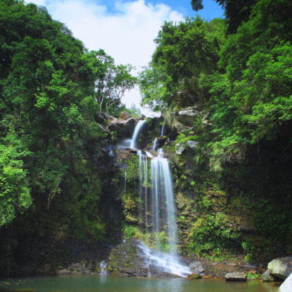
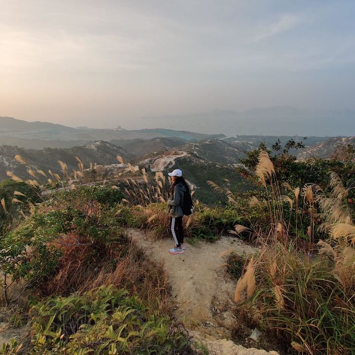
These are the best hikes and hiking trails in Hong Kong you need to complete before leaving the city.
In our humble opinion, Hong Kong’s hiking trails are the best way to explore isolated beaches, breathtaking nature and stellar city views. While rooftop bars, bustling city streets and Hong Kong’s rich cosmopolitan culture have their own charm, there’s nothing quite like a hike to get away from it all. The best part? There truly is a hike for everyone! From trails that are suitable for both beginners and experts to hikes you can do with your pup, hikes that’ll have you chasing waterfalls and more, your opportunities to spend time in the great outdoors are endless. Not sure where to start? Keep scrolling for your ultimate Hong Kong hiking trail bucket list…
Read More: The Best Beach Hikes In Hong Kong
Jump To:
Hong Kong Hiking Tips
The Very Best Hong Kong Hikes
Hong Kong Hiking Tips
Before you set off on your hike, have a read of our top Hong Kong hiking tips that’ll help you make the most of your day out.
Before Your Hike
- Make sure to look up the difficulty of the trail route and bring a trail map with you. You should only embark on hiking trails that are appropriate for your ability level.
- Check the weather for high temperatures or unexpected rain.
- In general, hiking with a friend is much safer than going alone
- Dress in hike-appropriate clothing and shoes.
What To Pack For Your Hike
- A fully-charged phone and camera (put it in a waterproof bag if you’re worried about rain).
- A simple first aid kit (with extra sunblock and bug spray).
- Plenty of water (and snacks if you’re out for the day)
- A swimsuit and a spare shirt — you could come across a waterfall.
During Your Hike
- Always stick to the designated hiking trail path.
- Use sunscreen (even if it’s cloudy), bug spray (to keep mosquitos at bay) and after-bite balm (we like Mopidick-s Lotion!).
- If you do get into trouble on your hike, there are often PCCW emergency phones near trailheads, and emergency crews are reassuringly well-practised at getting people out of emergency situations.
- Don’t take any unnecessary risks (safety before IG!).
Read More: Hong Kong Day Trips To Fill Your Weekends With
The Very Best Hong Kong Hikes

Best Hiking Trail For Beginners Who Still Want The Views — Dragon’s Back Ridge, The Hong Kong Trail
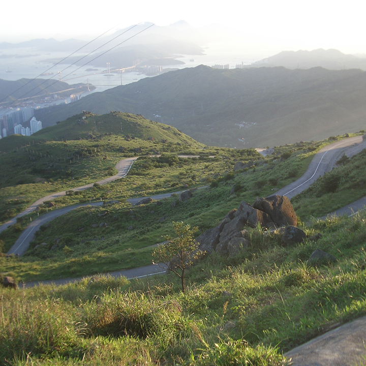
This is one of the most popular hiking trails in Hong Kong, and rightly so. As the easiest hike on the list, it is short, simple and incredibly scenic. The best thing about the Dragon’s Back trail is its accessibility — all you have to do is take the MTR to Chai Wan and start walking. You can easily fit this hike into a morning or afternoon, so it’s perfect for those busy Hong Kong schedules.
The first section of this hiking trail consists of stairs through Cape Collinson Cemetery, and once you finish those, it’s a one or two-hour hike along the ridge overlooking southern Hong Kong Island — a total breeze! Certain parts of the trail are wooded and boast beautiful plant life, whilst the rest of the hike is on a ridge overlooking the sea. The highest point on the trail is only 284 metres, but the views are worthy of a much more difficult hike. If it’s a cloudy day you can still enjoy the slopes, but you may not see as far into the distance.
Trail Directions
See here for full directions.
Sassy Tip: At the end of the trail, you’ll reach a bus stop. To head back to Central, take the Number 9 bus towards Shau Kei Wan MTR. Alternatively, we like to take the Number 9 bus the other way towards Shek O for some well-deserved beach time.
Not ready to stop? If you’re feeling ambitious and have extra time, you can continue your hike onwards towards the Tai Tam Reservoir, where you’ll get to see even more of Hong Kong’s landscape.
Read More: The Best Beginner Hikes In Hong Kong
Best Hiking Trail To See Unique Villages, Forests & Urban Beaches — Lamma Island
This is a lovely day trip, with several easy hiking trails to complete. Most of the paths are paved, there are vistas around every corner, and the villages and beaches have a distinct character (one beach overlooks the power plant). The main trail is one of the only ways to get between the villages on land; since Lamma is not accessible by car, walkers and bikers are everywhere.
Trail Directions
If it’s your first time to Lamma, we recommend completing the Lamma Island Family Trail. Make sure to start the trail at Sok Kwu Wan, and end at Yung Shue Wan where there is a larger village with more restaurants. Check out the beaches on the way there, then have a leisurely dinner and drinks overlooking the water. See here for full directions.
Already done the Family Trail? Being a small island, you can easily wander around the network of trails and discover hidden gems without ever being too far from the way home. Head south of Sok Kwu Wan for some simple but less-travelled trails with deep forests, Buddhist shrines and beaches – since there are fewer walkers in this area, you’ll feel like even more of an explorer!
Sassy Tip: Make sure to catch the right ferry! There are two Lamma Island ferries that run from Central — one that goes to Sok Kwu Wan, and another that goes to Yung Shue Wan. Head here for the timetables. You can also catch a ferry to Lamma Island from Aberdeen that goes to Yung Shue Wan.
Read More: The Best Waterfall Hikes In Hong Kong
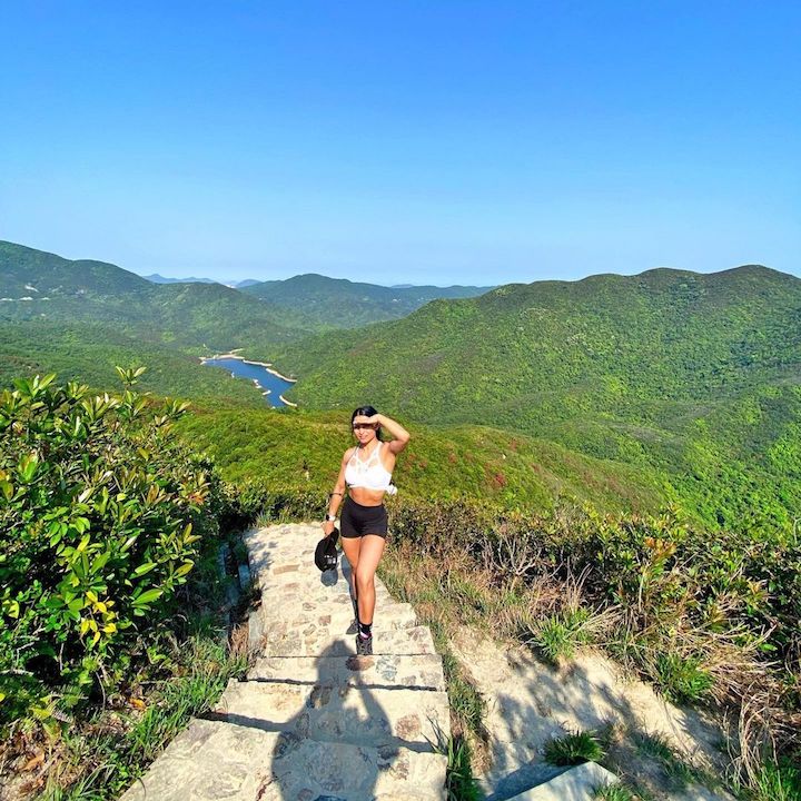
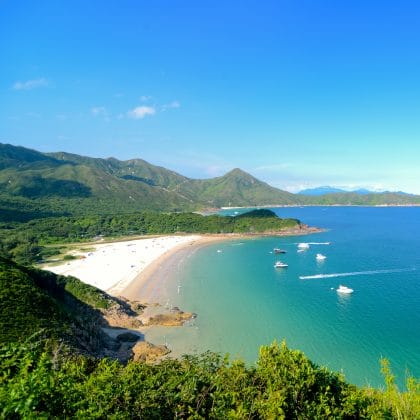
Best Hiking Trail For Secluded Beaches & Clifftop Views — MacLehose Trail: Stages 1 & 2
The MacLehose trail is 100km of hiking that stretches across the New Territories, east to west. Whilst the full trail is a great bucket list goal for experienced hikers, you definitely don’t have to do the full lot to enjoy the beauty of MacLehose. We recommend embarking on stages one and two, which feature the most beautiful tropical sections of the hiking trail.
If you begin the trail from stage one, start the day early. Stage one is 10km and stage two is 13km. There are places to catch transport (ferries and mini buses have sporadic service along the trails), but you should plan your transportation times in advance — the journey to start the hike is long in itself (it can take an hour or more on public transport from Central).
However, once you do eventually get there, you will never want to leave! Make sure you pack a swimsuit — stage one of the trail starts at the High Island reservoir, where you can sneak in some fun cliff jumping in Sheung Luk stream. After the swim, the hike is full of rolling hills and ocean views, complete with islands dotting the sea.
Stage two of the trail might be even more spectacular. As you begin to travel north, you’ll see the most famous beach in Hong Kong – Tai Long Wan. Continue on the trail to pass by the deserted village of Chek Keng, which is completely empty except for a ferry pier (which takes you to HKU), and dilapidated buildings still containing family portraits and tea sets — make sure you have a camera for the eerie village and the spectacular tropical views.
Trail Directions
See here for full directions
Sassy Tip: Didn’t make it as far as you hoped? Or perhaps you want to make a weekend of it? Break up your hike with a night of camping. Head to the restaurant at Tai Long Wan to rent a tent.
Read More: Your Guide To Tai Long Wan – What To Do, See & Eat
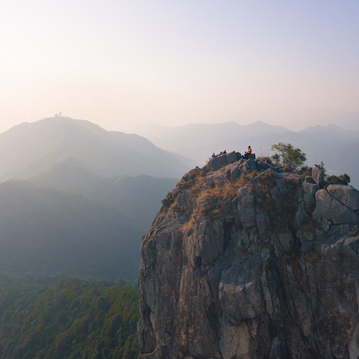
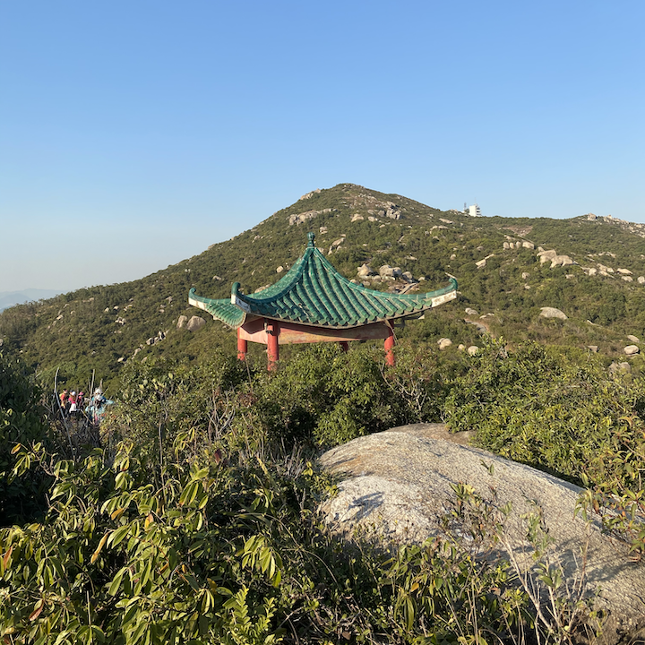
Best Hiking Trail For History (And Monkeys!) — MacLehose Trail: Stage 5, Lion Rock
This hiking trail has an amazing variety of sights — from historic artefacts to wild monkeys! The first part of the trail is fairly easy and goes along the Gin Drinker’s Line, where the Commonwealth troops defended Hong Kong against the Japanese in WWII. You can see trail markers and pillboxes all along this hike, with historic sites alternating with shrines, and both blending into the surroundings. After this first section of the trail, you’ll walk along a road and pass a café where you can grab some food; after that, the hike really begins!
As you continue on the trail, you’ll see an option to go to Lion Rock — definitely do this! This stage of the MacLehose trail is a little more difficult than the first sections but if you climb to the top of Lion Rock, you can see all of Kowloon and Hong Kong Island.
The historic monuments and views from Lion Rock aren’t all that this trail has to offer. Keep going on the path and you’ll come to a weather observatory, and then a nature walk that takes you to Sha Tin. About halfway along this, you’ll encounter a full monkey colony (with even more monkeys if you continue onto stage six of the trail). You’ll get some fantastic photographs but be careful, as loud noises and tempting food can make them aggressive.
Trail Directions
To start at the beginning of stage five, take the MTR to Choi Hung, then a taxi to Gilwell Campsite. Walk past the campground until the end of the road, where you will see a sign for the beginning of stage five of the trail. Stage five conveniently ends at a major road with a bus stop, where the number 81 bus will take you all the way back to Austin MTR station.
Sassy Tip: Pack a picnic to enjoy on your stop at Lion’s Rock. Talk about lunch with a view!
Read More: Hikes With A History – The Best Historic Walking Trails In Hong Kong

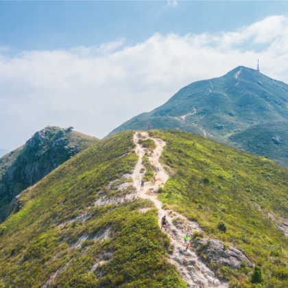
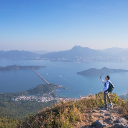
Best Hiking Trail For Experienced Hikers Who Love A Steep Climb — Lantau Peak
There are dozens of great hikes to do on Lantau Island (such as the iconic Sunset Peak), but if you’re keen on climbing mountains, our top hike pick is Lantau Peak. At 934 metres, it’s the second-highest peak in Hong Kong and the climb is stunning if, at times, gruelling. It’s a must for any hiker who wants a challenge.
Every time the ground levels off on this trail, you’ll hope you’re almost there… you’re probably not, but you are rewarded with dramatic sweeping slopes where you can see the villages on the south side and the airport to the north as you ascend! If you climb this trail on a cloudy day, the accomplishment of scaling 934 metres is intoxicating.
Trail Directions
There are two main trail routes to reaching Lantau Peak:
- Starting the trail from the Big Buddha, see here for directions
- Starting the trail from Tung Chung Gap, see here for directions
You can also lengthen the hike by starting the trail in Tung Chung and going up Sunset Peak first (the third highest point in Hong Kong). Continue along the trail to reach Lantau Peak. See here for directions.
Sassy Tip: After you’ve reached the summit, we recommend hiking straight down to a beach on the south side. Nothing feels better than jumping into the ocean after a five-hour hike. There are also great restaurants near most of the beaches, so you’ll get a reward for your hard work.
Read More: Hong Kong’s Most Challenging Hikes
Best Hiking Trail For A Serious Workout — The Twin Peaks & Violet Hill Trail
Yes, there are 1,000 steps on this trail. But it’s doable. And worth it. We promise. Take it slow, with as many rests as you need on the climb, and you will be rewarded with unreal views of Stanley and the outlying islands.
The trail starts with a long, gradual hike up to Violet Hill. Before you ask — no, this doesn’t count as any of the steps. As you descend the trail toward Repulse Bay, you will see an ominous indent running up the middle of the mountain in front of you — those are the steps. If you get to the base of the twins and decide you’ve had enough on your first go, there is a bailout point where you can take a right down into Repulse Bay. If you’re ready to tackle the never-ending staircase, it’s straight up the mountain. This is just the first twin, but don’t worry, the second is only about a quarter as big as the first. Once you reach the second summit, it’s all downhill to the road leading into Stanley!
Trail Directions
From Exchange Square, take the Number 6 or Number 66 bus to Tai Tam Reservoir Road (Parkview). Alternatively, taxi it straight there (this is one trailhead that all taxi drivers will know!).
Starting from Parkview, take a left onto the main street and stay on that side of the road. You will see trail markers for the Hong Kong Trail on the opposite side of the street. About 50 metres past those signs on your side of the road, you will see a trail map at the bottom of some stairs leading into the woods adjacent to Parkview. Then simply follow the signs.
The trail finishes on Stanley Gap Road at the Wilson Trail bus stop.
Sassy Tip: If you want to go down to Stanley to celebrate your athletic achievement at a waterfront restaurant, take any of the buses or a taxi from the same side of the road where you have finished. To head back to Central, cross the street and take a right to the bus stop where you can take the 6 or the 6A back into town.
Read More: The Best Hong Kong Hikes That End With A Meal
Editor’s Note: “Your Ultimate Hong Kong Hiking Trail Bucket List” was originally published in 2013 by Tania Shroff and was most recently updated in July 2024 by Team Sassy.
Main image courtesy of Tim Durgan via Pexels, image 1 courtesy of Fashila Kanakka for Sassy Media Group, image 2 courtesy of Drone and DSLR, image 3 courtesy of Sakina Abidi for Sassy Media Group, image 4 courtesy of CJB Scholten via Wikimedia Commons 3.0, image 5 courtesy of Tiffany Ku, image 6 courtesy of Drone and DSLR, image 7 courtesy of Sabina B (@sabina.bhattara1) via Instagram.


